$410,000
Us Highway 27
Leesburg, FL 34748
Property type
Lot size
Price / sq ft
HOA dues
Days on market
Flood zone
About this home
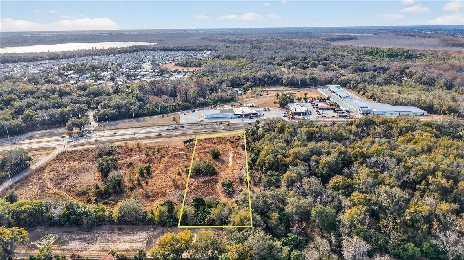
2 +/- Acres located on busy U.S. Hwy. 27 in the major growth corridor of Leesburg with a traffic count hitting almost 50,000 a day. Property current lies within Lake County with likely annexation into Leesburg. Property is ideal for many Commercial uses and has City of Leesburg Utilities nearby and contains 175’ of U.S. Hwy. 27 frontage. All of the site is high and dry and currently in Flood Zone X
Estimated monthly payment
Estimate only. Taxes use the listing's reported amount where available; insurance is a Florida-average estimate. Your actual payment will vary — run a full calculation or talk to a lender.
Price & listing history0 days on market
- Status: ActiveMar 13, 2026
- Listed$410,000Mar 13, 2026
- Price increased$410,000
Virtual Tour
Facts & features
- Property type
- Land
- Status
- Active
- Days on market
- 0
- Cumulative DOM
- 365
- County
- Lake
- Price/sq ft
- $5
- Lot size
- 87,242 sq ft
- Lot category
- 2 to less than 5
- Flood zone
- X
- Annual taxes
- $1,608 (2025)
- Parcel #
- 02-20-24-0002-000-07800
- Zoning
- CP
- MLS #
- G5109579
HOA & Financial
- Total monthly fees
- $0/mo
- Total annual fees
- $0
- Listing terms
- Cash, Conventional
- Ownership
- Fee Simple
Exterior & Construction
- Road surface
- Asphalt, Paved
Utilities
- Sewer
- None
- Water source
- None
- Utilities
- Electrical Nearby
Listing Details
- Listing date
- 2026-03-06
- On market date
- 2026-03-13
- Original list price
- $410,000
- MLS area
- 34748 - Leesburg
- Listing AOR
- Lake and Sumter
- Status changed
- 2026-03-13
- Tax legal description
- FROM INTERSECTION OF 210 FT S OF S LINE OF GOV LOT 2 WITH E R/W LINE OF US HWY 27 RUN S 88-14-56 E ALONG N'LY R/W LINE OF ENGLISH RD A DIST OF 400.04 FT TO A POINT THAT IS 100 FT W OF W LINE OF MORNINGVIEW SUB PB 20 PG 20 N 0-0-0 W PARALLEL TO AND 10 0 FT W OF W LINE OF SAID SUB A DIST OF 458.69 FT FOR POB CONT N 0-0-0 W ALONG SAID PARALLEL LINE A DIST OF 171.50 FT S 88-50-25 W 521.60 FT TO E'LY R/W LINE OF US HWY 27 THENCE SE'LY ALONG SAID E'LY R/W LINE OF US HWY 27 & A POINT ON A CURVE CONCAVE TO THE E HAVING A CENTRAL ANGLE OF 01-45-07 & A RADIUS OF 5661.65 FT THENCE RUN ALONG THE ARC OF SAID CURVE & SAID R/W LINE AN ARC DIST OF 173.12 FT SAID ARC HAVING A CHORD BEARING OF S 09-04-39 E & A CHORD DIST OF 173.12 FT N 88-50-25 E
Flood risk
Minimal-risk area outside the mapped floodplain. Flood insurance is optional and typically low-cost.
Source: FEMA flood zone reported on the listing. Confirm current designation at FEMA Flood Map Service Center.
Location
Directions
Property is 1/10 mile North of the intersection of US Highway 27(S 14th Street) and English Road on the right.
More homes like this
$395,000
6722 Mesker Pl
The Villages, FL 34762
3 bd · 2 ba · 1,477 sqft
The Villages
MLS# G5111293
$388,000
1896 Mcmurtrie Loop
The Villages, FL 34762
3 bd · 2 ba · 1,579 sqft
The Villages
MLS# G5113280
$361,915
10129 Huntingnet Way
Leesburg, FL 34748
4 bd · 3 ba · 2,210 sqft
Groves At Whitemarsh
MLS# O6413526
$361,915
5824 Cliffbow Loop
Leesburg, FL 34748
4 bd · 3 ba · 2,210 sqft
Groves At Whitemarsh
MLS# O6413519
Listings courtesy of Stellar MLS as distributed by MLS GRID
IDX information is provided exclusively for consumers’ personal, non-commercial use and may not be used for any purpose other than to identify prospective properties consumers may be interested in purchasing.
Based on information submitted to the MLS GRID as of March 14, 2026 at 1:02 AM ET. All data is obtained from various sources and may not have been verified by broker or MLS GRID. Supplied Open House Information is subject to change without notice. All information should be independently reviewed and verified for accuracy. Properties may or may not be listed by the office/agent presenting the information.
Ryan Solberg, Broker · MaxLife Realty LLC · FL License #BK3354351 · Equal Housing Opportunity · Full disclaimer · DMCA