$975,000
6720 Jim Davis Road
Parrish, FL 34219
Property type
Lot size
Price / sq ft
HOA dues
Days on market
Flood zone
About this home
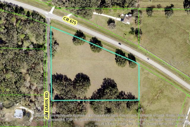
Prime opportunity, with location, potential, and growth all in one! This 6.75-acre corner lot boasts 684’ frontage on CR 675 and is currently zoned A offering multiple possibilities of usage. The property also has Future Land Use designation of UF-3, unlocking greater potential for future development. With several nearby residential developments and more on the way, the population is fast growing, now is the time to act. Don’t miss out on this strategic investment in a thriving area.
Estimated monthly payment
Estimate only. Taxes use the listing's reported amount where available; insurance is a Florida-average estimate. Your actual payment will vary — run a full calculation or talk to a lender.
Price & listing history356 days on market
- Status: ActiveMay 20, 2025
- Listed$975,000May 20, 2025
- Price increased$975,000
Virtual Tour
Facts & features
- Property type
- Land
- Status
- Active
- Days on market
- 356
- County
- Manatee
- Price/sq ft
- $3
- Lot size
- 294,030 sq ft
- Lot category
- 5 to less than 10
- Flood zone
- AE (12081C0184F)
- Annual taxes
- $2,875 (2024)
- Parcel #
- 420200008
- Zoning
- A
- MLS #
- A4652441
HOA & Financial
- Total monthly fees
- $0/mo
- Total annual fees
- $0
- Listing terms
- Cash, Conventional
- Ownership
- Fee Simple
Exterior & Construction
- Road surface
- Asphalt
Utilities
- Sewer
- None
- Water source
- None
- Utilities
- Electricity Available, Sewer Available, Water Available
Community
- Pets allowed
- Yes
Listing Details
- Listing date
- 2025-05-20
- On market date
- 2025-05-20
- Original list price
- $975,000
- MLS area
- 34219 - Parrish
- Listing AOR
- Sarasota - Manatee
- Status changed
- 2025-05-20
- Tax legal description
- NW1/4 OF SW1/4 OF SE1/4 LESS ROAD P-8; ALSO LESS THAT PORTION OF ABOVE DESC PROP LYING N OF ST RD 675, ALSO KNOWN AS RUTLAND RD PI#4202.0000/8
Flood risk
FEMA Special Flood Hazard Area (1% annual-chance / “100-year” floodplain). Flood insurance is generally required by mortgage lenders.
Source: FEMA flood zone reported on the listing. Confirm current designation at FEMA Flood Map Service Center.
Location
Directions
From US 301 turn east on CR 675/Rutland Rd and continue to Jim Davis Rd on the right, lot is located at corner of CR 675 & Jim Davis Rd.
More homes like this
$835,000
10019 Degas Ter
Bradenton, FL 34212
3 bd · 3 ba · 2,240 sqft
Watercolor Place
MLS# A4692406
$639,000
337 Snapdragon Loop
Bradenton, FL 34212
5 bd · 3 ba · 2,858 sqft
Greyhawk Landing Ph 2
MLS# A4693396
$699,700
13006 50th Ct E
Parrish, FL 34219
4 bd · 3 ba · 2,796 sqft
Gamble Creek Estates
MLS# TB8479155
$650,000
1160 Mill Creek
Bradenton, FL 34212
3 bd · 3 ba · 1,760 sqft
Not In A Subdivision
MLS# A4693007
Listings courtesy of Stellar MLS as distributed by MLS GRID
IDX information is provided exclusively for consumers’ personal, non-commercial use and may not be used for any purpose other than to identify prospective properties consumers may be interested in purchasing.
Based on information submitted to the MLS GRID as of May 11, 2026 at 2:58 PM ET. All data is obtained from various sources and may not have been verified by broker or MLS GRID. Supplied Open House Information is subject to change without notice. All information should be independently reviewed and verified for accuracy. Properties may or may not be listed by the office/agent presenting the information.
Ryan Solberg, Broker · MaxLife Realty LLC · FL License #BK3354351 · Equal Housing Opportunity · Full disclaimer · DMCA