$249,900
00 Us Hwy 19
Hudson, FL 34667
Listing updated: January 26, 2026 at 9:28 AM ET
Property type
Lot size
Price / sq ft
HOA dues
Days on market
Flood zone
About this home
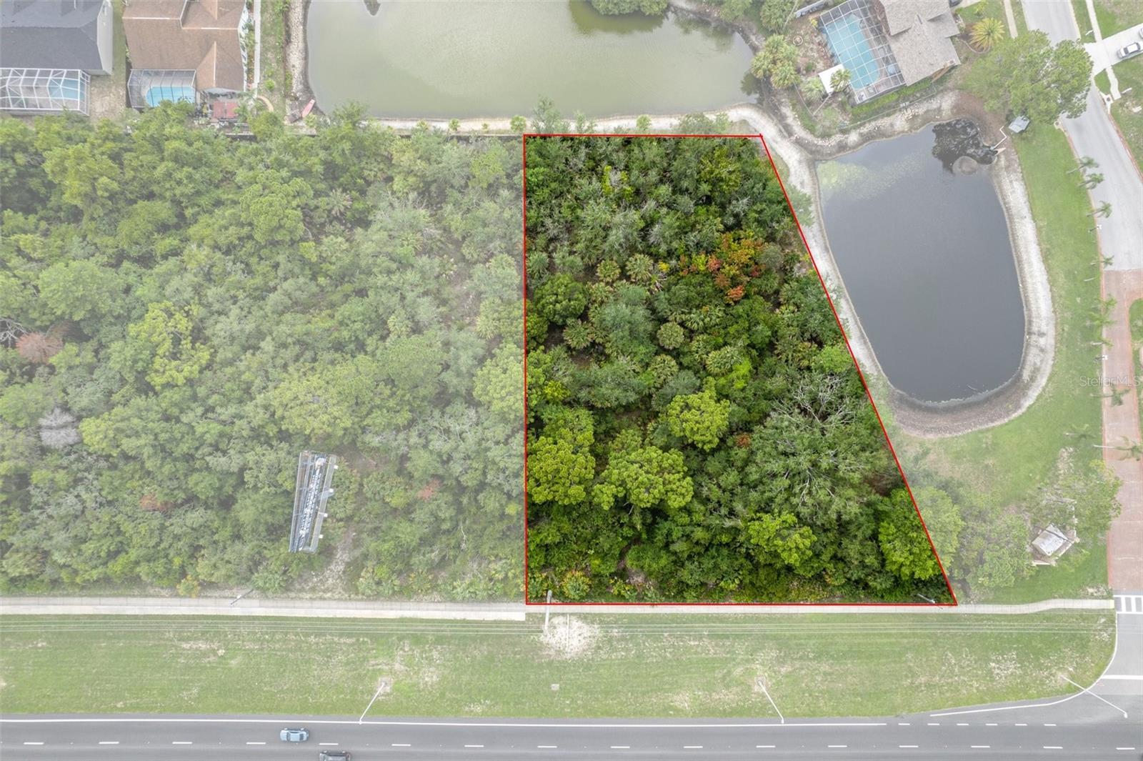
Commercial Vacant Land On The Corner Of US Hwy 19 And Landmark Drive On .98 Acres. Zoning Is C2 With 44500 Vehicles Passing By Daily. The Vacant Commercial Lot Next Door Is Also Available For A Total Of 1.55 Acres And 330 Sq Ft Of Frontage On US Hwy 19. Go And Show! Call Today For More Information!
Estimated monthly payment
Estimate only. Taxes use the listing's reported amount where available; insurance is a Florida-average estimate. Your actual payment will vary — run a full calculation or talk to a lender.
Price & listing history555 days on market
- Status: ActiveJan 31, 2025
- Listed$249,900Jul 18, 2024
- Price increased$249,900
Facts & features
- Property type
- Land
- Status
- Active
- Days on market
- 555
- County
- Pasco
- Price/sq ft
- $6
- Lot size
- 42,871 sq ft
- Lot category
- 1/2 to less than 1
- Flood zone
- X (12101C0017G)
- Annual taxes
- $1,693 (2023)
- Parcel #
- 17-24-06-000.0-003.00-002.0
- Zoning
- C2
- MLS #
- W7866647
Ask about this home
Have a question? Ask the broker directly.
Ryan Solberg answers personally — no call center, no spam. Your question goes straight to him.
HOA & Financial
- Total monthly fees
- $0/mo
- Total annual fees
- $0
- Listing terms
- Cash, Conventional
- Ownership
- Fee Simple
Exterior & Construction
- Road surface
- Paved
Utilities
- Sewer
- None
- Water source
- None
- Utilities
- BB/HS Internet Available, Cable Available, Electricity Available, Phone Available
Listing Details
- Listing date
- 2024-07-18
- On market date
- 2024-07-18
- Original list price
- $249,900
- MLS area
- 34667 - Hudson/Bayonet Point/Port Richey
- Listing AOR
- West Pasco
- Status changed
- 2025-01-31
- Tax legal description
- COM NW COR OF SE1/4 OF NW1/4 TH S00DG 33' 00"W 1169.67 FT TH N89DG 36' 15"E 680.39 FT TO WLY R/W US 19 TH N23DG 46' 00"E 1078.69 FT FOR POB TH N66DG 14' 00"W 250.00 FT TH N23DG 46' 00"E 112.27 FT TH N88DG 24' 00"E 276.68 FT TH S23DG 46' 00"W 230.80 F T TO POB AKA PARCEL C OR 8181 PG 1853
Flood risk
Minimal-risk area outside the mapped floodplain. Flood insurance is optional and typically low-cost.
Source: FEMA flood zone reported on the listing. Confirm current designation at FEMA Flood Map Service Center.
Location
Directions
US Hwy 19 near the intersection of Landmark Drive and US Hwy 19.
More homes like this
$249,900
7194 Sealawn Dr
Spring Hill, FL 34606
3 bd · 2 ba · 1,152 sqft
Weeki Wachee Acres
MLS ID #TB8516298
Listing provided by Stellar MLS
$245,000
1252 Garret Ave
Spring Hill, FL 34606
3 bd · 2 ba · 1,454 sqft
Spring Hill
MLS ID #TB8506515
Listing provided by Stellar MLS
$299,900
7604 Mako
Hudson, FL 34667
2 bd · 2 ba · 1,478 sqft
Sea Pines
MLS ID #W7885210
Listing provided by Stellar MLS
$320,995
4320 Bayridge Ct
Spring Hill, FL 34606
3 bd · 2 ba · 1,316 sqft
Spring Hill
MLS ID #TB8475513
Listing provided by Stellar MLS
Listings courtesy of Stellar MLS as distributed by MLS GRID
IDX information is provided exclusively for consumers’ personal, non-commercial use and may not be used for any purpose other than to identify prospective properties consumers may be interested in purchasing.
Based on information submitted to the MLS GRID as of January 26, 2026 at 9:28 AM ET. All data is obtained from various sources and may not have been verified by broker or MLS GRID. Supplied Open House Information is subject to change without notice. All information should be independently reviewed and verified for accuracy. Properties may or may not be listed by the office/agent presenting the information.
Ryan Solberg, Broker · MaxLife Realty LLC · FL License #BK3354351 · Equal Housing Opportunity · Full disclaimer · DMCA