$650,000
6601 Riverside Drive
Yankeetown, FL 34498
Listing updated: May 12, 2026 at 1:02 AM ET
Property type
Lot size
Price / sq ft
HOA dues
Days on market
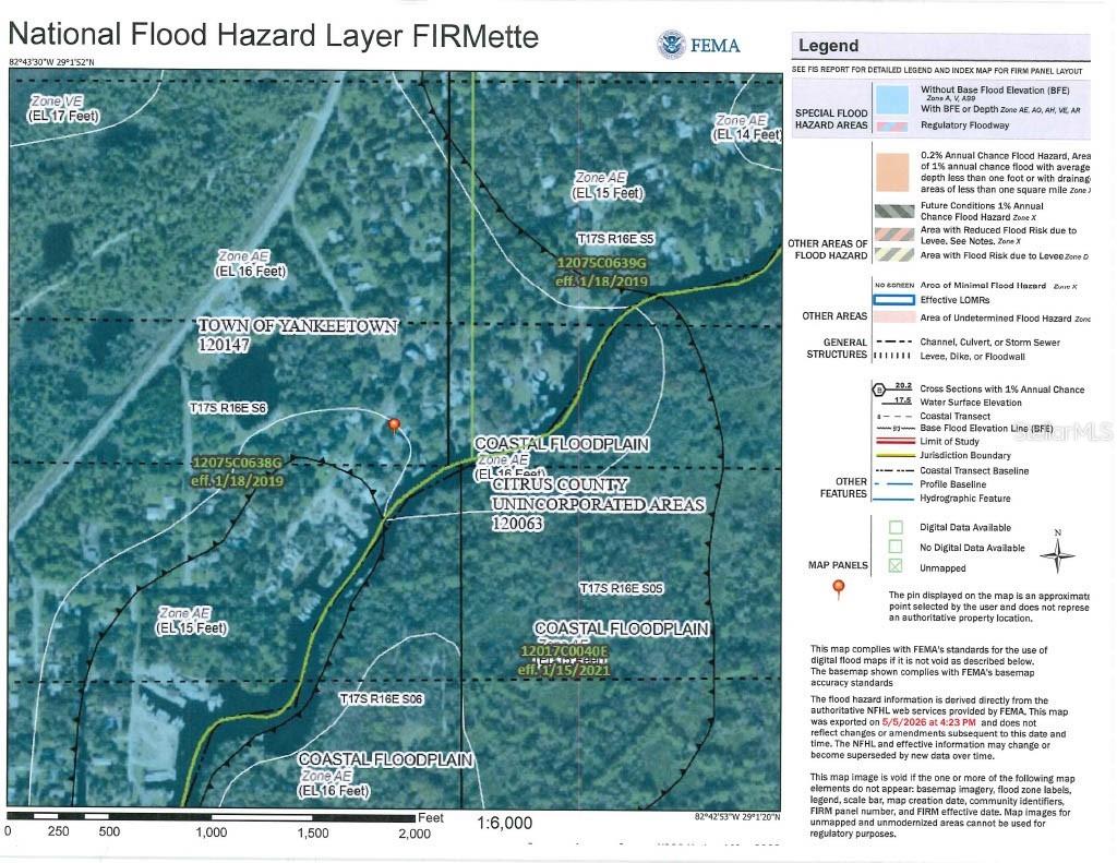
Flood zone
About this home
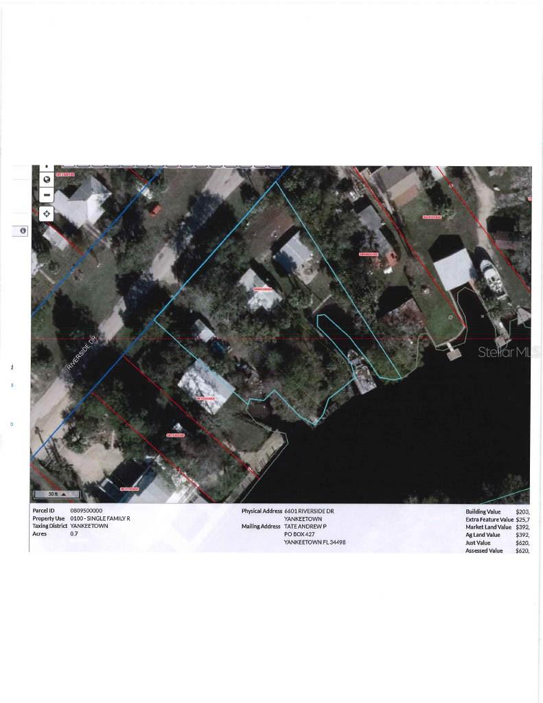
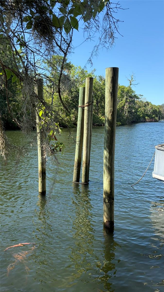
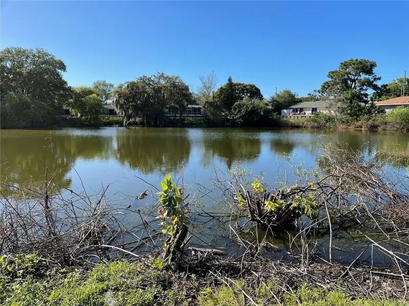
Unique waterfront commercial parcel with .7 acres on the Withlacoochee River. Zoned Waterfront Dependent Commercial. Property is in disrepair and no value is attributed to buildings. Over 70' cut-in boat slip with concrete seawall. Could be used as a Marina, boat docking, restaurant, sale of seafood, hotel, retail shops. No value attributed to houses & buildings - docks in disrepair - don't walk on them. Parcel has 3 lots assessed at 624,041 in 2025.
Estimated monthly payment
Estimate only. Taxes use the listing's reported amount where available; insurance is a Florida-average estimate. Your actual payment will vary — run a full calculation or talk to a lender.
Price & listing history0 days on market
- Status: ActiveMay 11, 2026
- Listed$650,000May 11, 2026
- Price increased$650,000
Facts & features
- Property type
- Land
- Status
- Active
- Days on market
- 0
- Subdivision
- Riverside Sub
- County
- Levy
- Price/sq ft
- $21
- Lot size
- 30,492 sq ft
- Lot category
- 1/2 to less than 1
- Flood zone
- AE (12075C0638G)
- Annual taxes
- $12,078 (2025)
- Parcel #
- 08095-000-00
- Zoning
- CWD
- MLS #
- G5112223
Ask about this home
Have a question? Ask the broker directly.
Ryan Solberg answers personally — no call center, no spam. Your question goes straight to him.
HOA & Financial
- Total monthly fees
- $0/mo
- Total annual fees
- $0
- Ownership
- Fee Simple
Exterior & Construction
- Waterfront
- Yes
- Water access
- Yes
- Water view
- Yes
- Road surface
- Asphalt
Utilities
- Sewer
- Septic Tank
- Water source
- Public
- Utilities
- Public, Water Connected
Listing Details
- Listing date
- 2026-05-11
- On market date
- 2026-05-11
- Original list price
- $650,000
- MLS area
- 34498 - Yankeetown
- Listing AOR
- Lake and Sumter
- Status changed
- 2026-05-11
- Tax legal description
- 06-17-16 RIVERSIDE S/D LOTS 5 , 6 & 7-LESS TRIANGLE ALONG ELY LINE OF LOT 5 OR BOOK 1060 PAGES 197 & 198
Flood risk
FEMA Special Flood Hazard Area (1% annual-chance / “100-year” floodplain). Flood insurance is generally required by mortgage lenders.
Source: FEMA flood zone reported on the listing. Confirm current designation at FEMA Flood Map Service Center.
Location
Directions
US #19 N to L on 40 in Inglis to 66th Street. Turn left to Riverside Drive, turn right to property on left.
More homes like this
$349,000
5736 Colonial Dr
New Port Richey, FL 34653
2 bd · 2 ba · 1,542 sqft
Riverside Sub
MLS ID #W7874655, FUTURE HOME REALTY.
Listing provided by Stellar MLS
$465,000
9690 N Alder Ave
Crystal River, FL 34428
3 bd · 2 ba · 1,431 sqft
Crystal Manor Unit 03
MLS ID #OM724667, TROPIC SHORES REALTY LLC.
Listing provided by Stellar MLS
$599,900
35 Captains Cove Rd
Inglis, FL 34449
3 bd · 4 ba · 2,943 sqft
Captains Cove
MLS ID #W7883504, EXP REALTY LLC.
Listing provided by Stellar MLS
$619,000
34 Garden Mall Ct
Inglis, FL 34449
3 bd · 2 ba · 2,030 sqft
Garden Mall Unrec
MLS ID #OM721161, PREMIER SOTHEBY'S INTERNATIONAL REALTY.
Listing provided by Stellar MLS
Listings courtesy of Stellar MLS as distributed by MLS GRID
IDX information is provided exclusively for consumers’ personal, non-commercial use and may not be used for any purpose other than to identify prospective properties consumers may be interested in purchasing.
Based on information submitted to the MLS GRID as of May 12, 2026 at 1:02 AM ET. All data is obtained from various sources and may not have been verified by broker or MLS GRID. Supplied Open House Information is subject to change without notice. All information should be independently reviewed and verified for accuracy. Properties may or may not be listed by the office/agent presenting the information.
All or a portion of the multiple listing information is provided by Stellar MLS, from a copyrighted compilation of listings. The compilation of listings and each individual listing are © 2026 Stellar MLS. All rights reserved.
Ryan Solberg, Broker · MaxLife Realty LLC · FL License #BK3354351 · Equal Housing Opportunity · Full disclaimer · DMCA