
$395,000
Sw Hwy 484
Dunnellon, FL 34432
Listing updated: May 28, 2025 at 4:12 PM ET
Property type
Lot size
Price / sq ft
HOA dues
Days on market
Flood zone
About this home
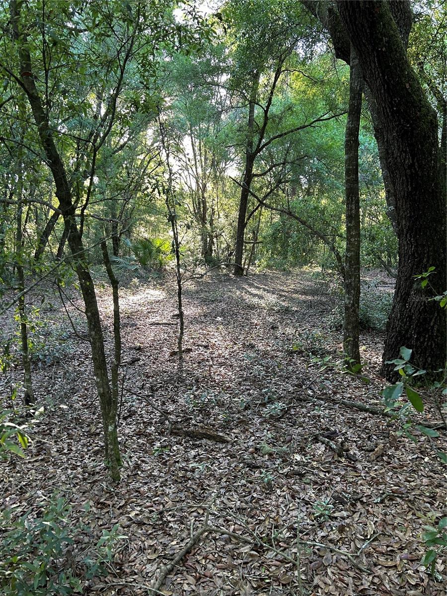
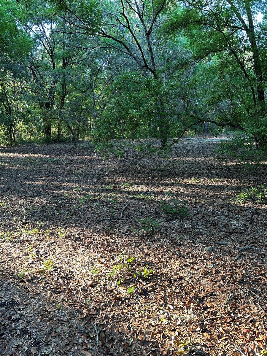
LOCATION LOCATION BEAUTIFUL 5 ACRE PRIME ACREAGE HIGH AND DRY 330 FT ROAD FRONTAGE ON CR 484 HIGHWAY. PROPERTY IS FENCED ON THREE SIDES.LOCATED ONLY ¾ OF A MILE FROM SR 200, WALMART, ADVENT HEALTH, TIMBER RIDGE ER ,DOLLAR STORE, RESTAURANTS AND MUCH MORE. LOTS OF ROOM FOR FUTURE BUILD. GREAT POTENTIAL AND POSSIBILITIES ON THIS BEAUTIFUL 5 ACRE LOT. Just minutes from Rainbow Springs State Park, the Marion County Airport and Ross Prairie State Forest. Zoned A-1 allowing for both Residential and Agricultural use.
Estimated monthly payment
Estimate only. Taxes use the listing's reported amount where available; insurance is a Florida-average estimate. Your actual payment will vary — run a full calculation or talk to a lender.
Price & listing history100 days on market
- Status: ActiveFeb 17, 2025
- Listed$395,000Feb 17, 2025
- Price increased$395,000
Facts & features
- Property type
- Land
- Status
- Active
- Days on market
- 100
- County
- Marion
- Price/sq ft
- $2
- Lot size
- 217,800 sq ft
- Lot category
- 5 to less than 10
- Flood zone
- X
- Annual taxes
- $1,369 (2024)
- Parcel #
- 35317-000-00
- Zoning
- A1
- MLS #
- OM695298
Ask about this home
Have a question? Ask the broker directly.
Ryan Solberg answers personally — no call center, no spam. Your question goes straight to him.
HOA & Financial
- Total monthly fees
- $0/mo
- Total annual fees
- $0
- Listing terms
- Cash
- Ownership
- Fee Simple
Exterior & Construction
- Road surface
- Paved
Utilities
- Sewer
- Septic Needed
- Water source
- Well Required
- Utilities
- Electrical Nearby, Other
Community
- Pets allowed
- Yes
Listing Details
- Listing date
- 2025-02-17
- On market date
- 2025-02-17
- Original list price
- $395,000
- MLS area
- 34432 - Dunnellon
- Listing AOR
- Ocala - Marion
- Status changed
- 2025-02-17
- Tax legal description
- SEC 34 TWP 16 RGE 20 THAT PART OF W 1/2 OF E 1/2 OF NE 1/4 OF SW 1/4 LYING N OF ROW OF SR 484
Flood risk
Minimal-risk area outside the mapped floodplain. Flood insurance is optional and typically low-cost.
Source: FEMA flood zone reported on the listing. Confirm current designation at FEMA Flood Map Service Center.
Location
Directions
TAKE SW 200 to Hwy 484 take right and property is on the right side approximately 1/4 mile down the road on 484. Two signs are on the property.
More homes like this
$349,800
15329 Sw 65th Terrace Rd
Ocala, FL 34473
4 bd · 2 ba · 2,079 sqft
Marion Oaks #9
MLS ID #OM726194, KELLER WILLIAMS CORNERSTONE RE.
Listing provided by Stellar MLS
$243,000
8795 Sw 108th St
Ocala, FL 34481
2 bd · 2 ba · 1,601 sqft
Oak Run Nbrhd 12
MLS ID #OM727499, BRICKS & MORTAR REAL ESTATE.
Listing provided by Stellar MLS
$290,000
9365 Sw 94th Loop
Ocala, FL 34481
3 bd · 2 ba · 2,063 sqft
On Top/World
MLS ID #NS1085595, ENGEL & VOLKERS NEW SMYRNA.
Listing provided by Stellar MLS
$375,000
6577 Sw 111th Loop
Ocala, FL 34476
3 bd · 2 ba · 2,409 sqft
Oak Run Fairway Oaks
MLS ID #OM727284, DECCA REAL ESTATE.
Listing provided by Stellar MLS
Listings courtesy of Stellar MLS as distributed by MLS GRID
IDX information is provided exclusively for consumers’ personal, non-commercial use and may not be used for any purpose other than to identify prospective properties consumers may be interested in purchasing.
Based on information submitted to the MLS GRID as of May 28, 2025 at 4:12 PM ET. All data is obtained from various sources and may not have been verified by broker or MLS GRID. Supplied Open House Information is subject to change without notice. All information should be independently reviewed and verified for accuracy. Properties may or may not be listed by the office/agent presenting the information.
All or a portion of the multiple listing information is provided by Stellar MLS, from a copyrighted compilation of listings. The compilation of listings and each individual listing are © 2026 Stellar MLS. All rights reserved.
Ryan Solberg, Broker · MaxLife Realty LLC · FL License #BK3354351 · Equal Housing Opportunity · Full disclaimer · DMCA